
125 years of collecting germplasm in 38 seconds
July 29, 2026
What nearly one million landrace records in Genesys can, and cannot, tell us about the history of collecting missions.
The data in Genesys is a valuable resource for people working on plant genetic resources for food and agriculture, as it can help researchers and policymakers explore patterns in conservation and use of germplasm. As with any large dataset assembled from many genebanks over many decades, its analytical value depends on the completeness and accuracy of the accession records.
To demonstrate the unique insights offered by Genesys data, Peter Giovannini, Coordinator of the Global Crop Conservation Strategies at the Crop Trust, explores the history of landrace collecting though an animated map, spanning more than a century. Each point on the map represents a location where germplasm was collected. As the animation progresses, it reveals how collecting activities expanded and concentrated in different parts of the world at different times.
Here, Peter explains how he created the visualization, what patterns emerged and why improving passport data remains so important:
As part of a project examining how the risk of crop diversity erosion can be modelled geographically, I wanted to get an idea of the time sequence in which the landrace material in Genesys had been collected.
My first step was to download all the Genesys data for landraces; this allowed me to analyze the data by grouping it by year of collection and by species. I then examined how the different data points were distributed geographically over time.
Before analysing: The importance of data completeness and quality
Of the more than 970,000 landrace accessions in Genesys, 346,000 records remained after excluding those with no date of collecting or with an incorrect date (for example year 2121). Of the initial 970,000 records, only about 440,000 have geographical coordinate data (longitude and latitude). After applying both criteria, 228,000 records remain with both a valid years of collecting and geo-data.
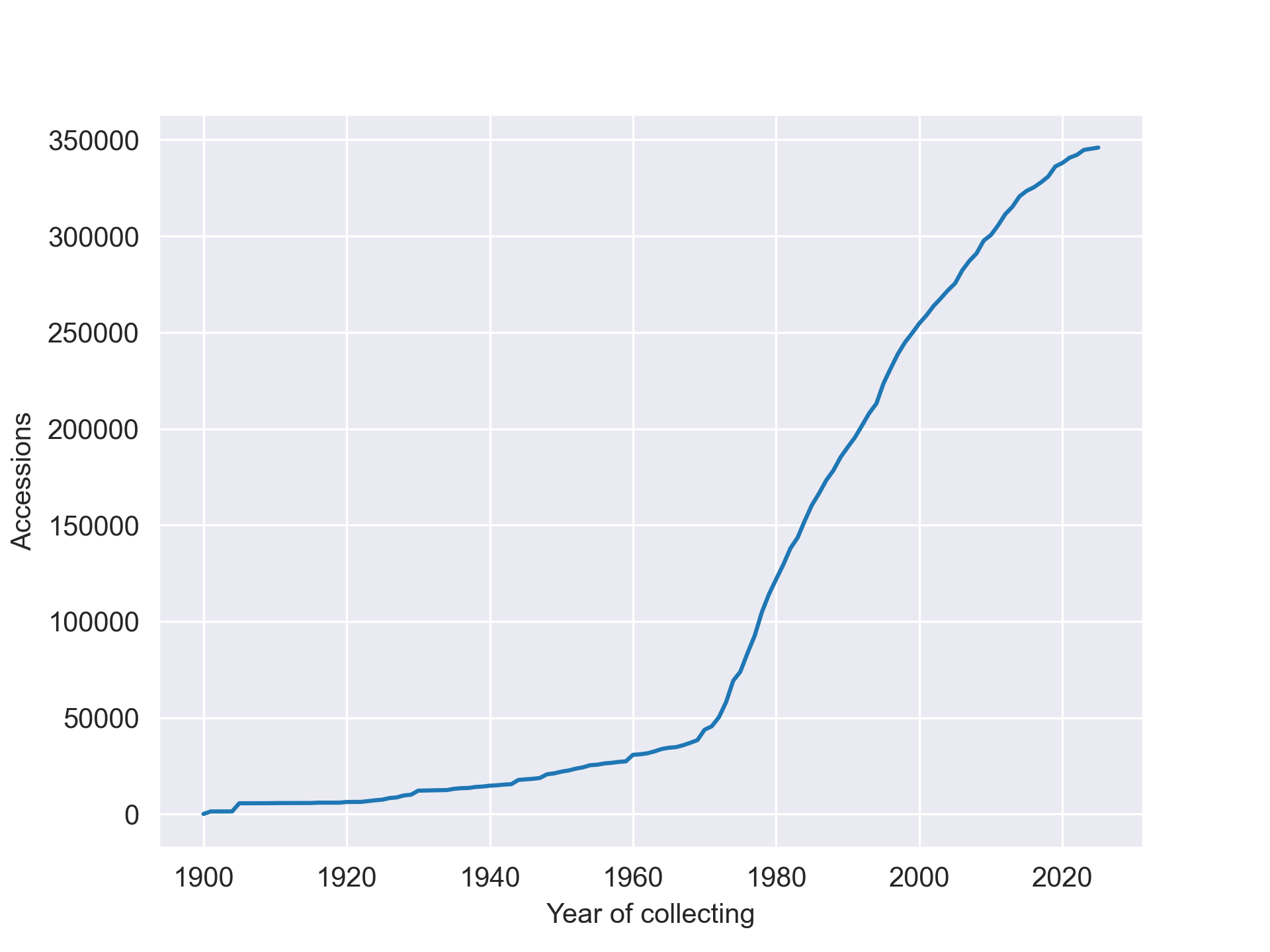
Figure 1. Accumulation plot showing the cumulative number of accessions by year of collecting. Data includes landrace accessions collected from 1900 onwards after accessions with missing or invalid dates were excluded.
Coordinate data also forms the basis for conducting spatial gap analyses to establish which sites should be prioritized for further collecting. This highlights the importance of including this information in passport data. Data inaccuracy is also problematic, as both coordinate data and collecting year are susceptible to error introduced at different stages in the creation and management of passport data. These errors introduce noise into the dataset and reduce the confidence in the results of the analysis. The figures presented here should therefore be understood as patterns in the data currently available through Genesys, rather than as a complete reconstruction of all germplasm collecting carried out worldwide.
Turning records into an animated map
With all the above caveats in mind, I mapped the collecting sites of the landraces conserved in genebanks, first dividing them by decade (one map for each decade). This allowed me to identify patterns in the data. Then, to get a more immediate sense of change over time, I created an animated map in which each frame corresponds to a year, and the collecting missions made in each year are shown alongside those from all preceding years, starting from 1900. The result is the animated visualization below, where each green dot is the site where an accession was collected.
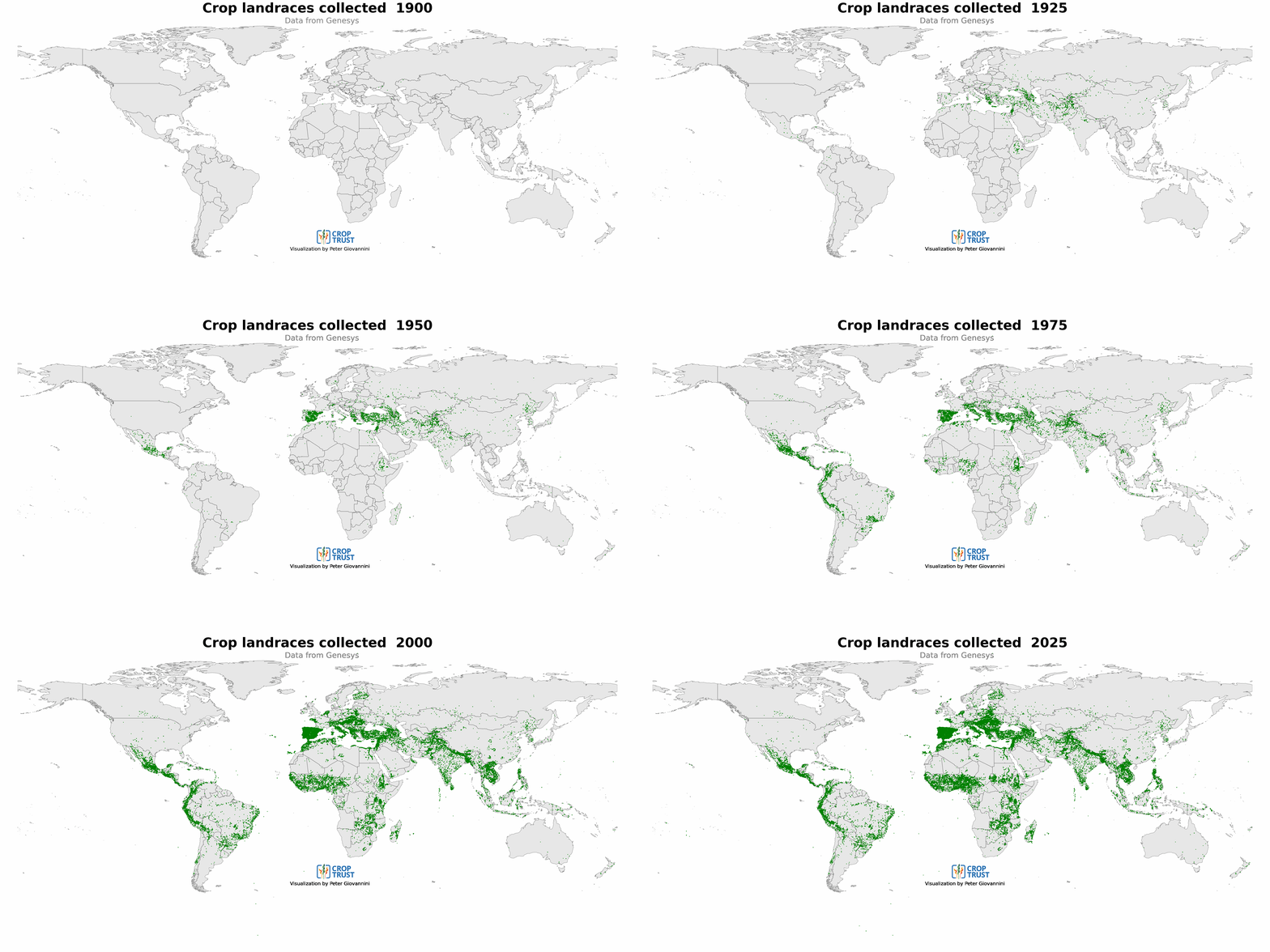
Figure 2. Animated map of landrace collecting sites documented in Genesys. Each frame represents one year, while points from preceding years remain visible. The animation covers the period from 1900 to 2025 in 38 seconds.
Several historical and geographical patterns become visible in the animation.
Maize collecting in Mexico
From 1943 through the 50s the map shows a concentration of collecting in Mexico. A closer look at the data indicates these are almost all Maize landraces conserved at CIMMYT, and they are likely the germplasm collected as part of the Mexican Agricultural Program established by the Rockefeller Foundation and the Mexican government. This program supported crop research and plant breeding in Mexico and contributed to the development of approaches that later expanded to other countries during the period known as the Green Revolution.
Growth of collecting missions
Collecting activities represented in the dataset increased significantly during the 70s, corresponding with the establishment of the International Board for Plant Genetic Resources (IBPGR) in 1974. IBPGR/IPGRI organized over 500 collecting missions, a work that was fundamental to the establishment of the global system of ex situ conservation.
From 2010 to 2025 the animation shows that many accessions were collected in Africa (rice, sorghum. pearl millet, okra and Vigna); in Europe (common bean), and Philippines (Vigna). Collecting also took place in several parts of Latin America including Peru, Brazil, Central America, as well as in Nepal and Tajikistan. Several of these collecting missions were made as part of the CGIAR Genebank Platform to fill gaps identified through gap analyses, while others were undertaken through national genebank collecting programmes.
These records show that collecting continues to play an important role in crop diversity conservation. New collecting may respond to geographical gaps, changes in farming systems, threats to traditional varieties or the need to secure material that remains underrepresented in ex situ collections.
What can we learn from 38 seconds?
The animation compresses 125 years of data into 38 seconds. It provides an engaging way to explore how the geographical coverage of landrace collections documented in Genesys has changed over time.
However, the most important message may be what the animation does not show: a missing point does not necessarily mean that no collecting took place in a particular location or year. The material may not be conserved by a data provider in Genesys, the corresponding record may lack coordinates or the collecting date, or the information may not yet have been digitized and published.
Similarly, a dense concentration of points may reflect intensive collecting, particularly detailed documentation or granulated data, the availability of records from a major collection holder, or a combination of these factors.
By improving and sharing passport data, genebanks do more than make individual accessions discoverable. They help build a clearer picture of what is conserved within the global system of ex situ conservation, where crop diversity has been collected, what may still be missing and where future conservation efforts could be directed.
Explore landrace accessions and other accession-level data through Genesys here.